
Enrich Credible Failure Modes & Submissions
Traceable AI for Mine site Monitoring
We turn siloed surveillance and documentary data into auditable mine operations and closure decisions.
Trusted by leading mining operators for continuous monitoring of tailings storage, dam, and slopes.
.png)
.png)
.png)
.png)
Purpose-built for Mining Use-cases
.png)
Catch anomalies across the footprint, early enough to act on them. Helps avoid stoppages and false alarms.
.png)
Turn the closure and assurance filing from months of consultant hours into regular, defensible submissions.
.png)
Monitor for credible failure modes and flag risks before they surface, with complete transparency of where to focus mitigation efforts.
.png)
Pin contamination source and flow paths, among other features, across decades of data, so long-term liability stays defensible.
The Move from Reactive to Proactive Mine Monitoring Keeps Stalling.

Mines generate huge monitoring datasets across teams and vendors, but too often it isn’t acted on, just siloed until the next reporting cycle.
.png)
Meeting standards means synthesizing 100+ data sources manually. Delays cost money, and a single error can put an operating license or an engineer's sign-off at risk.
.png)
Evidence sits across internal teams and external consultants, and every round of review adds weeks.

Critical-mineral demand quadruples by 2040 (IEA). But specialists age out and mining-engineering graduates fell by 1/3rd in four years. (NRCan)
From diverse sources to location-anchored intel.
TRAIL ingests all the data a site produces and structures it into an entity-based knowledge graph, anchored by location, that grows with every data integration and over time.
.png)
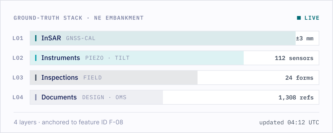
Our GNSS-calibrated InSAR is a proprietary strength that anchors the ground-truth layer. It is one of many layers the workspace reasons over.
Playbooks
Codified workflows that run the same analysis the same way, every time.
Our expert team develops and tunes playbooks to your site and your team’s requirements, so recurring work stops being manual.
.png)
Piezometric Water Level Assessment
.png)

Piezometer trends vs. design-basis phreatic surfaces to flag pore-pressure risk to dam stability.
Groundwater Quality Assessment
Piezometer trends vs. design-basis phreatic surfaces to flag pore-pressure risk to dam stability.
Surface Water Quality Assessment
Piezometer trends vs. design-basis phreatic surfaces to flag pore-pressure risk to dam stability.
Tailings Facility Water Balance
Piezometer trends vs. design-basis phreatic surfaces to flag pore-pressure risk to dam stability.
Dam Surface Deformation
Piezometer trends vs. design-basis phreatic surfaces to flag pore-pressure risk to dam stability.
Dam Safety Review Support
Piezometer trends vs. design-basis phreatic surfaces to flag pore-pressure risk to dam stability.
Geochemical & ARD/ML Assessment
Piezometer trends vs. design-basis phreatic surfaces to flag pore-pressure risk to dam stability.
Annual Regulatory Submission Compiler
Piezometer trends vs. design-basis phreatic surfaces to flag pore-pressure risk to dam stability.
Inspection & Site-Change Review
Piezometer trends vs. design-basis phreatic surfaces to flag pore-pressure risk to dam stability.
Climate & Hydrology Trend Assessment
Piezometer trends vs. design-basis phreatic surfaces to flag pore-pressure risk to dam stability.
Mine-native risk planning.
Understand your site’s behaviour over time, what are signals it wants you to look at, and how do you step in to resolve or plan mitigation.
Each layer measured at the resolution the feature warrants, updated as new data arrives, and traced to a source and a date.
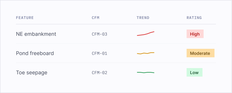
Every asset feature has modelled ways it can fail: a dam by overtopping, internal erosion, or slope instability; a berm by surface erosion or settlement; a road by washout. These decide which signals matter.
.png)
Rules turn a change rate into a rating and a threshold crossed into a change in risk. It is the human-validated ledger that shows risks the team should manage.
Support across the mine life cycle.
TRAIL keeps watch across active facilities via different monitoring data.
TRAIL compiles submission packages against GISTM, ICMM, CDA, MAC TSM, MSHA, ANCOLD, and other national codes.
TRAIL preserves the evidence base and runs low-touch monitoring, so long-term custodians inherit accessible context.
See TRAIL on a closure or dam-safety project.
Bring a site you are wrestling with, or let us walk you through one we know well. We present you how TRAIL & our team have been helping mining and infrastructure projects.
.png)
CEO and Co-Founder
.png)
CPO and Co-Founder
Frequently Asked Questions
Who uses TRAIL?
Risk engineers, underwriters, asset owners, and engineering teams who conduct desktop studies or site monitoring for infrastructure and mining projects.
What if TRAIL gets something wrong or hallucinated?
TRAIL shows reasoning and citation/sources for every conclusion. The chain is preserved for review and audit. Users verify outputs like they would any junior’s work.
How is our data protected?
TRAIL is deployed in secure cloud environments with SOC 2 Type II compliance. Data is encrypted in transit and at rest. We can deploy in your private cloud for additional control.
What’s the typical ROI Timeline?
Time savings visible within first pilot. Compounding value from preserved evidence and faster dispute resolution.
What types of files and data can TRAIL process?
Upload PDFs, PPTs, CSVs, GeoJSON, Rasters or connect data via API. Ask your queries and export responses with citations to reporting tools.
Send us a message
We’ll reach out within 48 hours.
.webp)
.png)


.svg)