

Table of contents
Introduction
The world that insurers support is changing fast. Infrastructure and hyperscale construction are being built at a record pace. Data center campuses, warehouse complexes, logistics hubs, and renewable energy corridors are on the rise.
The global market for data center construction was at US$245 B in 2024 and is projected to reach US$371 B by 2030, growing at a CAGR of 7.2%.
BusinessWire
These projects demand something insurers have rarely had: clear visibility into site conditions and the ability to monitor what causes delays. Without it, underwriters struggle to assess the true financial exposure each project poses. The consequences show up as Delay in Start-Up (DSU) claims, often the largest exposure on a policy, and construction liability disputes that can stretch for years. These are some of the largest losses insurers absorb.
Yet insurers are being asked to underwrite tomorrow's complexity with yesterday's knowledge and tools. The gap between what's being built and what can be confidently evaluated is widening.
Insurance Workflows Need An Upgrade
When a submission for such hyperscale construction projects comes in, the underwriting process looks straightforward on paper:
- The broker sends documents.
- The underwriter screens the package.
- A risk engineer reviews the technical material.
- Additional information is requested.
- A consultant interprets the evidence.
- Everything circles back for final pricing and conditions.
But in practice, it’s complex. Underwriters start with partial information. Risk engineers are handed dense reports and unstructured documents without a clear risk summary of the site. This makes the case for physical site visits. And once things get on the ground, the process becomes logistically complicated and time-consuming. Consultants provide point-in-time interpretations based on limited evidence, but limited reports about changes over time throughout the project.
Throughout this loop, site condition risks remain inconsistent or scattered.
The strain is amplified by rapid additions to the portfolio as construction projects expand faster than ever. One engineer may review dozens of complex sites each week, leaving little room for in-depth analysis.
At the same time, climate variability is shifting groundwater patterns, intensifying shrink-swell cycles, and changing the behavior of soft soils that static reports cannot capture. Insurance is facing more site conditions, ground instability, and delay-related losses with less capacity to evaluate them. And there are repercussions that insurers face:
- Triage slows down when submissions are messy
- Inconsistent underwriting due to varying interpretations
- Engineering reviews become expensive or repetitive
- Exposures are accepted without full visibility
- Difficult decisions: what is covered and what is not
- Disputes over “differing site conditions.”
The need is clear on all ends. Insurers want speed. Engineers want accuracy. Compliance wants traceability. Traditional workflows force trade-offs amongst all three.
Loss Patterns in Infrastructure Projects for Insurers
Construction Liability
When ground-related failures surface years after completion: drainage issues, structural or foundational movement, the central question becomes: did the issue already exist, or did it emerge later? Without pre-bind evidence of site behavior, insurers are forced to navigate these disputes through a slow, costly, and often inconclusive process.
"It can take years to conclude whether the policy was profitable."
Delay in Start-Up (DSU Insurance)
For an owner’s loss to be covered under DSU, the delay must be directly caused by physical damage (landslide, fire, structural failure, or other insured events). Delays from other means (labor strikes, supply chain issues, poor management, or pre-existing conditions) are, in most cases, excluded or have limited coverage.
But this creates a fundamental challenge of constant progress monitoring throughout construction, so that insurers can distinguish covered delays from uncovered ones when needed. This task is generally outsourced to a specialized surveyor or multiple forensic engineering consultants.
The process seems good in theory, but when real claims arrive, the game changes completely. Retrospective progress analysis following an insured incident is time-consuming, costly, requires weaving together different data sources, reports, and, most importantly, cross-verification. It all comes down to finding the correct cause that triggered the event. Because a comparatively small insured physical damage can trigger hundreds of millions in DSU.
The Hidden Driver of Change Orders & Delays: Ground Instability
Behind many construction change orders and delays lie ground conditions: Foundation Movement, Drainage Failure, Grading Error, Groundwater Uplift, Undocumented Fill, and Long-Term Deformation.

These aren't edge cases; they're recurring patterns across data centers, logistics parks, energy corridors, and public infrastructure. The challenge is that the evidence required to understand them never exists in a form that insurers can use. There are three main reasons why accurate evidence remains unnoticed:
1. Sparse, Point-Based Data
Every submission depends on a handful of boreholes and a geotechnical report. Those boreholes are accurate at the exact points drilled, but they don't capture how bearing capacity changes 20-30 meters away, how groundwater moves seasonally, or whether sections sit on undocumented fill. Two underwriters reading different geotechnical reports for similar sites can walk away with entirely different interpretations. Decisions end up relying on professional intuition, not spatial visibility.
2. Fragmented Evidence with No Common Standard
Information is scattered across sources: bore logs, grading plans, CAD drawings, inspection notes, drone photos, soil lab results, and 150-300 page PDF reports. None aligns to a common format. None flows into a unified pipeline. Risk engineers have to spend considerable time piecing together basic facts about what the site is, how it evolved, and what might be hiding below the surface.
3. No Multi-Year Ground Behavior Record
Perhaps the biggest gap: insurers rarely see how the ground actually behaves over time. There's no multi-year deformation record, no history of terrain modification, no visibility into groundwater recharge patterns, and no ability to compare pre-event and post-event conditions.
These three gaps leave risk engineers and underwriters making judgment calls on partial or overwhelmingly scattered information. True costs only emerge years later through construction delays, post-construction failures, and long-tail claims.
Existing Tools Each Solve a Fragment of the Problem
The issue isn’t a lack of inputs. It’s the absence of a single, auditable evidence layer that brings everything together: the specificity of borehole logs, the insights buried deep in submitted documents, correlation with wide-area ground deformation, site conditions throughout project phases, water risk, and historical changes.
Introducing TRAIL Playbooks for Insurance Workflows
What is TRAIL for Insurance?
TRAIL is an AI co-worker for insurers. It’s an agent that reads all the dense reports and unstructured documents, interprets satellite-derived ground motion maps, cross-references multi-hazard layers, and assembles all of it into an underwriting-ready package with clear, traceable reasoning.
It helps the underwriting team skip days of document hunting. It enables the claims team to evaluate site conditions without on-site inspections to verify claims.
Using TRAIL playbooks, they can find the critical signals for insurance-ready analysis.
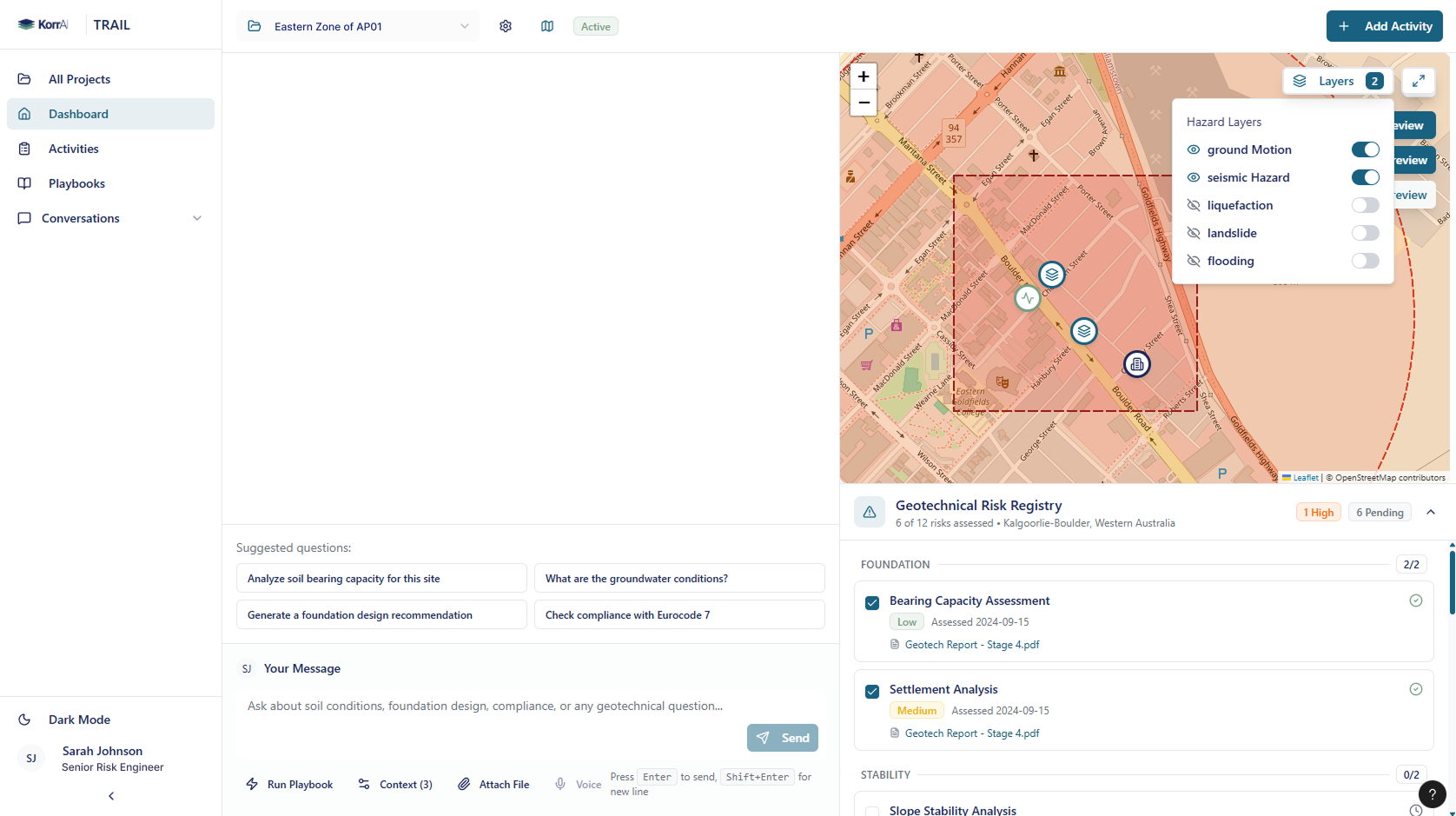
See how TRAIL gives insurers the visibility they've been missing: TRAIL - AI Workers for Construction Insurance
What are TRAIL Playbooks?
Playbooks are standardized workflows inside TRAIL that assess different risk aspects. Each playbook is built on measured, multi-year geospatial evidence delivered through source-backed summaries, risk classes, and maps that directly support underwriting, engineering referral, and claims analysis.
{{services-widget}}
How Playbooks Support Construction Insurance
TRAIL Playbooks strengthen the existing insurance workflows. For construction liability and large infrastructure projects, they provide underwriters, risk engineers, and claims teams with a single, consistent evidence layer they can rely on from first submission to post-event analysis.
Underwriting & Engineering Referral
Playbooks give underwriters and risk engineers a clear, consolidated view of ground stability, grading history, and water-related sensitivities around a proposed project. Instead of scanning scattered documents or relying on isolated boreholes, the team sees:
- mapped stability trends
- areas of subsurface variability
- water-driven accumulation or recharge zones
- portions of the site shaped by past earthworks
This helps sharpen early decisions: when to request more information, when to apply conditions, and when to escalate for engineering review. More importantly, it provides traceable justification for those decisions, grounded in measurable evidence rather than judgment alone.
Claim Auditing & Forensic Engineering
When ground-related disputes arise years after construction, settlement, uplift, drainage failures, or neighbor impact - Playbooks help reconstruct what the site looked like before, during, and after the project.
This includes:
- Pre-existing deformation and water risk
- How earthworks or grading changed the terrain
- Whether movement patterns accelerated post-construction
- Which conditions were foreseeable at bind
The ability to compare pre- and post-event ground behavior gives claims teams a neutral evidence baseline for determining whether the loss stemmed from pre-existing conditions, construction activities, or external factors. It shortens disputes, clarifies responsibility, and supports more defensible outcomes.
Delay in Start-Up Assessment
Using third-party high-resolution satellite imagery and KorrAi’s change analysis, TRAIL enables progress monitoring throughout construction. With auditable evidence of project status, insurers can find answers to questions like:
- Did the site conditions actually delay construction and the commercial operations?
- How much of the total delay is attributable to the insured event versus other factors?
- What was the project status immediately before the event was reported?
- Were there pre-existing reasons for delays that should be excluded from the claim?
Case Study: How KorrAI Helps Zurich’s Construction Liability Underwriting
Context
Zurich E&S provides a tangible example of how remote ground intelligence is already reshaping underwriting. Within Construction Liability, Zurich operationally uses KorrAI’s Ground Motion Risk Index (GMRI) as part of its risk-enrichment workflow. While subsidence is excluded under Property as part of Earth movement, it remains a significant third-party liability exposure for contractors, design-build firms, and engineers.
This is where pre-bind visibility has been thin for a long time.
Solución
Para abordar esta brecha, Zurich integra GMRI directamente en su proceso de enriquecimiento de la Declaración de Valores (SOV). GMRI se añade para ocho estados de alto riesgo donde se ha demostrado que el movimiento del terreno influye materialmente en los resultados de responsabilidad civil.
Este conjunto de pruebas ampliado alimenta la Puntuación de Calidad de Riesgo de Responsabilidad Civil de Zurich, que determina las vías de escalamiento. GMRI se convierte efectivamente en una parte estructural del proceso de toma de decisiones: una forma de identificar rápidamente los sitios con inestabilidad del terreno elevada y de garantizar que las derivaciones y condiciones se basen en riesgos medibles en lugar de interpretaciones anecdóticas.
Impacto
La integración de GMRI en el flujo de trabajo de Zurich ha servido como evidencia consistente para la suscripción de responsabilidad civil en la construcción. El despliegue de Zurich valida a GMRI como una herramienta operativa, escalable y de nivel asegurador.
Con los Playbooks de TRAIL, las aseguradoras pueden pasar de una señal única y potente a una capa de evidencia totalmente estructurada para proporcionar una suscripción consistente, documentada y defendible.
Reflexiones finales
El riesgo del subsuelo siempre ha estado presente; lo que faltaba era una forma fiable de detectarlo de manera temprana, precisa y a la escala que exige el sector asegurador. GMRI demostró que la evidencia del terreno recopilada durante varios años puede fortalecer significativamente las decisiones de responsabilidad civil en la construcción. TRAIL y sus Playbooks se basan en esa base, integrando inteligencia documental, evolución del sitio, comportamiento de las aguas subterráneas y contexto de peligros en un flujo de trabajo trazable.
Para las aseguradoras que navegan por el rápido crecimiento de la construcción y el aumento de las pérdidas relacionadas con el terreno, esto representa un camino práctico a seguir: mayor visibilidad, decisiones más consistentes y un mejor control de la exposición a largo plazo.
Si desea explorar cómo TRAIL puede apoyar sus programas de suscripción e ingeniería de riesgos, puede enviar una solicitud de interés para TRAIL o programar una reunión con nuestros expertos para obtener más información.
Share this post


Written By


Rahul Anand
CEO y cofundador
Rahul es el director ejecutivo y cofundador de KorrAI. Emprendedor en serie, anteriormente ha creado empresas exitosas en Internet de consumo e IoT. Ahora, se ha centrado en combatir el hundimiento del suelo, que se espera que afecte a más del 25% de la población mundial en las próximas décadas.

Rob McEwan
CPO y cofundador
Rob dirige el desarrollo de productos en KorrAI, donde se especializa en InSAR, teledetección y análisis geoespacial impulsado por AI. Con experiencia en geología y ciencia de datos, ha trabajado en exploración, minería y análisis basados en sistemas de información geográfica. Apasionado por la tecnología y la creatividad, disfruta de la fotografía infrarroja, la música y los proyectos prácticos de carpintería y automatización.
Written By

Team KorrAI


Riesgo de Movimiento del Terreno

Riesgo de Pilotaje

Riesgo de Agua y Drenaje

Evolución del Sitio

Inteligencia Documental
Suscríbase a nuestro boletín
De vez en cuando enviamos correos electrónicos con actualizaciones, nuestros últimos blogs y nuestras lecturas favoritas sobre InSAR y el lento paisaje del hundimiento del suelo.
Leído por los mejores profesionales en



¡Uy! Algo salió mal al enviar el formulario.


2026 KorrAI. Todos los derechos reservados.
IA trazable para proyectos de miles de millones.
Suscríbase a nuestro boletín
De vez en cuando enviamos correos electrónicos con actualizaciones, nuestros últimos blogs y nuestras lecturas favoritas sobre InSAR y el lento paisaje del hundimiento del suelo.
Leído por los mejores profesionales en
¡Uy! Algo salió mal al enviar el formulario.