
Table of contents
Introduction
Information on a mine site is a lot like a game of Telephone. Every handover between designers, Engineers of Record, operators, contractors, and regulators creates small shifts in the language used. These shifts compound and accumulate until the original meaning, name, or description of an object is hard to remember.
Several names may legitimately refer to the same feature- an embankment, a pond, etc. Every Engineer of Record has to study reports someone else wrote in their own vocabulary (and sometimes even language).
But unlike Telephone, there's no one correct message. The goal is to make sure every record, reading, and label still refers to the right feature as that feature changes.
The structure and approach that keep those connections in place is called an ontology. This article is about ontology in mining and what it does for the people managing site risk.
What Changes Over a Mine’s Life?
Mine sites change constantly. That includes:
- The features: Tailings dams are raised in multiple stages. Waste rock dumps grow lift by lift. Pits become deeper. New ponds and ditches appear. Some facilities close. Others are reclaimed.
- Their geometry: Every raise or lift changes a feature’s outline. After each raise, the dam in the same spot is a different structure. The raise method can also show how it might fail (and what to look out for).
- The data feeds: Instruments are replaced, monitoring contractors come and go, survey methods shift. New feeds such as satellite deformation monitoring get added to the mix years after operations have begun.
- People and vocabulary: A 1987 study examined the words people spontaneously chose for the same things. Two people picked the same term less than 20% of the time. People will always end up using different words and phrases to mean the same thing. At a tailings facility, reports may use "phreatic surface," "water table," and "pore pressure line" loosely, even though they don't mean the same thing.

What Happens When Site Information Does Not Line Up?
Consider these four records about the same part of an embankment:
- An inspection note flags seepage at the toe, referencing the toe position from before the last raise.
- A piezometer trend shows rising pore pressure. It is logged under an instrument ID from a new monitoring contractor.
- A satellite deformation map shows movement across the current downstream slope.
- The design report lays out foundation assumptions for the original starter dam footprint.
All four are talking about the same dam. But they refer to different outlines, different IDs, and different labels. Unless someone remembers that they connect, they won’t.
Mine Sites Need a Shared Knowledge Base
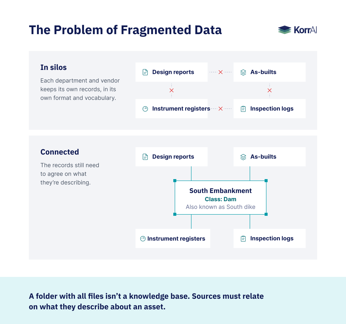
On most mine sites, there’s no single place where all site knowledge exists (at least inherently). Each department and vendor keeps its own records in its own format and vocabulary.
GISTM (Global Industry Standard on Tailings Management) asks operators to address this data fragmentation. Principle 2 calls for an interdisciplinary knowledge base that supports safe tailings management for the facility’s whole life, closure included.
But you can’t put every file in one folder and call it a knowledge base. The records still need to agree on what they’re describing. You need a shared way of classifying things.
That’s why we are talking about ontology.
What Is Ontology?
At a mine site, an ontology is a structured knowledge organization framework and naming convention that reflects everything at the site and the relationships between them. It describes all features, where they are located, and how they are related to each other, as well as to data and records.

The term "ontology" comes from philosophy and describes the study of the nature of being. In computer science, it describes a formal definition of concepts and relationships in a domain (Gruber, 1993). A site ontology for a mine builds on that definition.
How Ontology Works on a Mine Site
An ontology is built around entities, i.e., the actual infrastructure components on a site. This could be your south embankment, a piezometer, or a toe drain.
Physical features can be described by their class, geometry, site name, and other attributes. Documents, instruments, and data feeds do not all have a physical outline.
- Class: What type of feature it is, chosen from a list such as tailings storage facility, dam, pond, waste rock dump, or ore stockpile. Your south embankment belongs to the class “dam.” Classes carry meaning: a waste rock dump and an ore stockpile can look the same from above, but one holds material that is never processed, and they carry different kinds of risk.
- Geometry: Where the entity is, what are its boundaries, how does it change over time.
- Names and data: Different site names, labels or IDs that denote the same feature over the years, and the records, instruments, and data feeds linked to it.
Then relationships connect the entities and show how a change in one affects another.
From Ontology to a Knowledge Graph
Once a site's real entities and relationships are filled in, you get a knowledge graph. A mine-site knowledge graph connects features to reports and readings about them.
In it, nodes represent entities of interest. The links between them represent their relationships (Hogan et al., 2021).
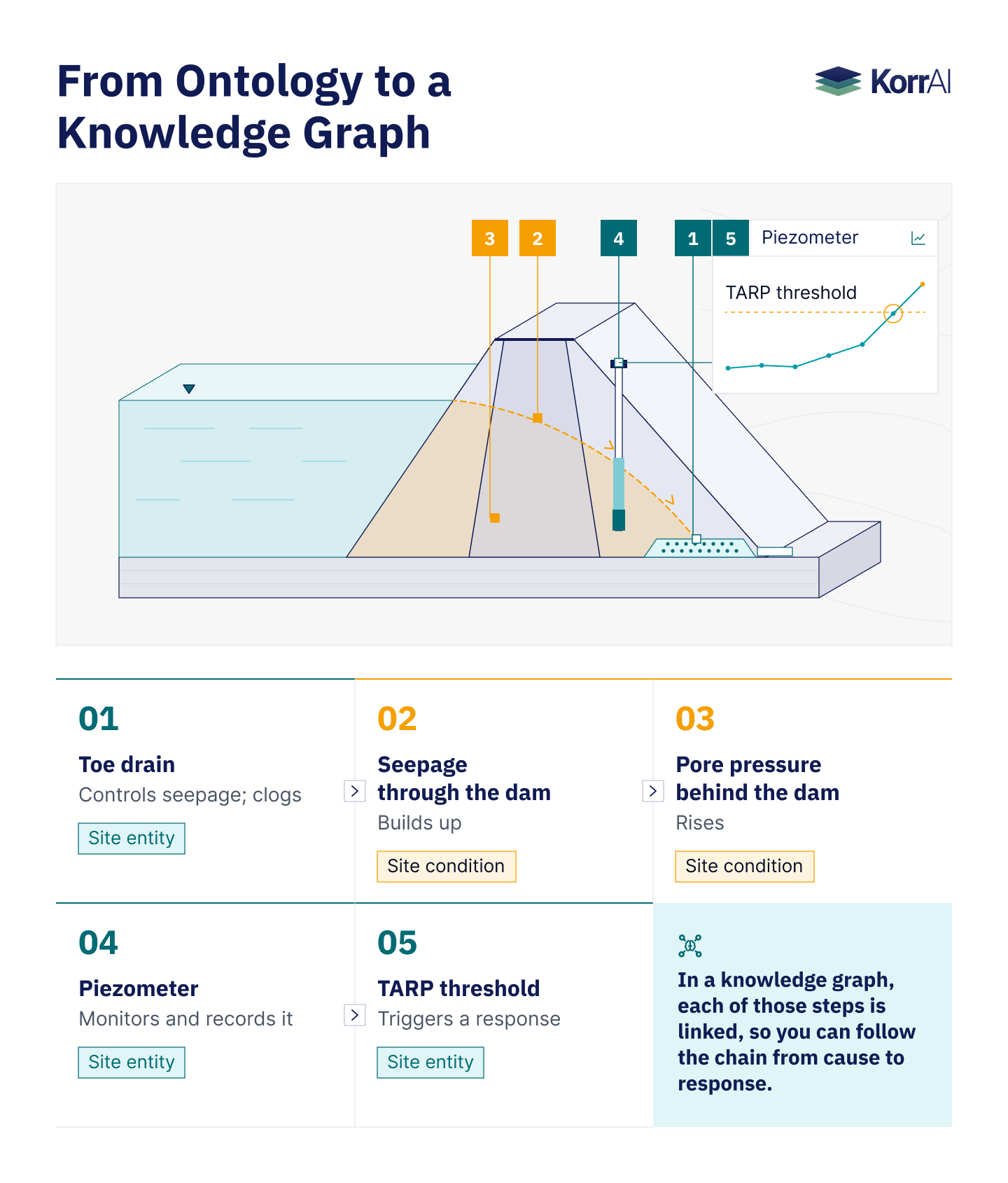
For instance, a clogged toe drain lets seepage build up, which raises pore pressure behind the dam. A piezometer records that rise. Then a trigger action response plan (TARP) threshold decides what happens next.
In a knowledge graph, each of those steps is linked, so you can follow the chain from cause to response.
A keyword search can find records with similar wording. A graph-based search can also follow relationships recorded in the graph, even when records use different terms and when geometries change over time.
Identity and Geometry in Mine Ontology
In an ontology, every feature is known by its identity (what it is) and its geometry (its physical shape and extent).
A car can be repainted or have its body panels replaced, but the vehicle identification number (VIN) stays the same. The south embankment is similar. Its identity as a tailings dam stays fixed, though it is named with four different names, or IDs, in multiple sources. The picture of potential risk keeps changing as the geometry, thresholds, and response measures change.
A feature’s geometry exists in multiple outlines, each newer than the last. When the dam is raised, the new outline is added with its survey date.
The earlier ones are kept. Its inspection history, instrument records, and failure modes remain attached to the dam itself rather than to any one outline of its shape.
A site model can segregate a feature's identity from its time-varying geometry. In order to reconstruct a site as it appeared on a specific date, the system must also retain and provide access to those geometries.
How TRAIL Helps Build and Maintain Mine Ontology
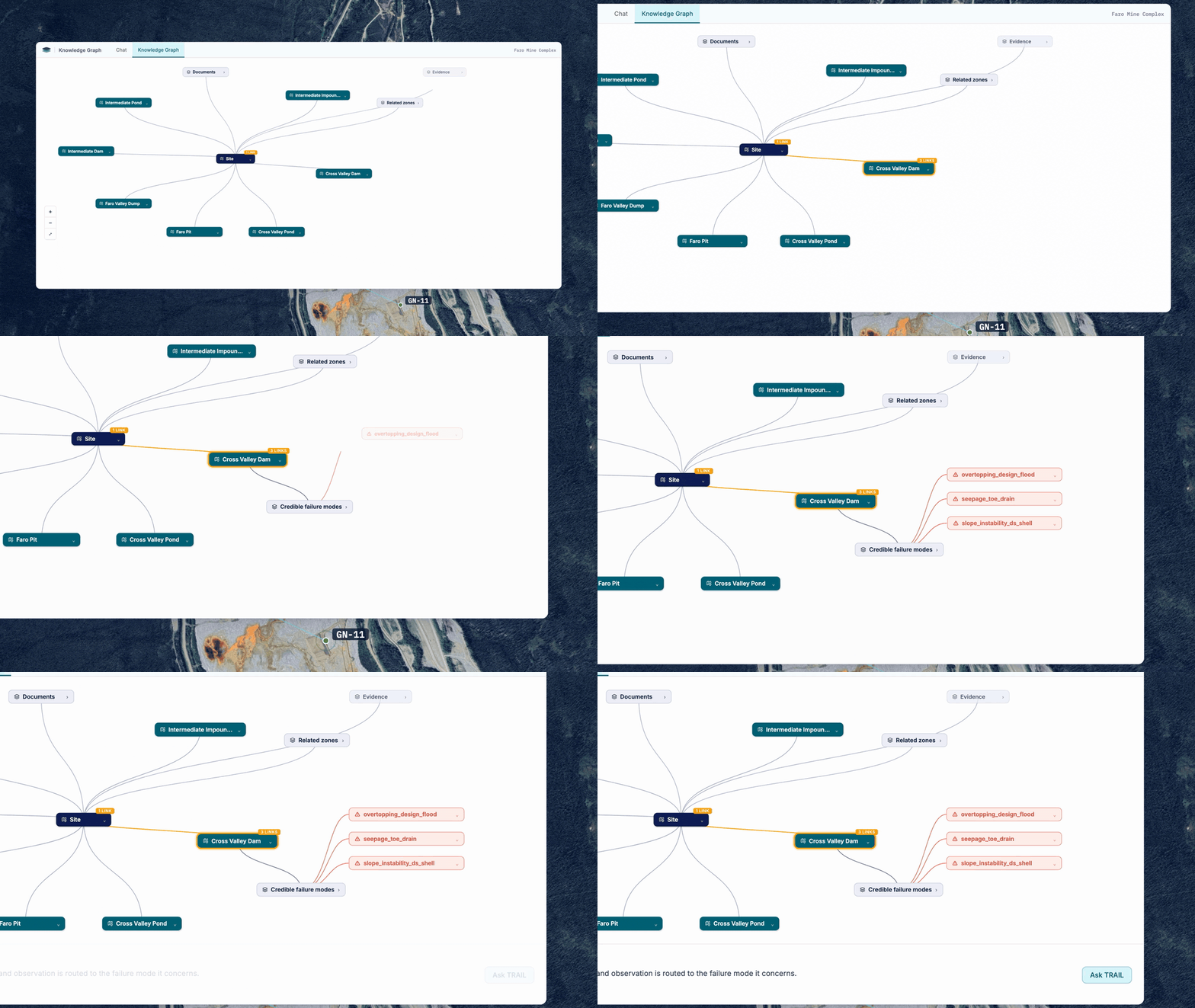
TRAIL breaks a mine site into zones such as dams, ponds, and waste rock dumps. Zones are then classified according to the names given by the site team. Once the KorrAI team classifies areas of the mine, site personnel confirm the classification.
A knowledge graph connects the zones with the pieces of evidence as well as potential failure modes. Instead of looking through countless documents to find supporting evidence, engineers can ask TRAIL or easily navigate the knowledge graph to assess potential failure modes.
How our approach works
Classify physical features while maintaining site vocabulary
A feature keeps its operator-given name (“South Embankment”) and is slotted into a controlled class (”Dam”). Because of this, classification and downstream risk logic stay consistent across the site. The proposed model also gives zones permanent IDs rather than using names.
Fit existing site maps into a cohesive structure
Setup starts with GIS layers, closure plans, engineering drawings, imagery, and site knowledge.
The documented workflow uses names and spatial relationships to propose classes and parent–child links. Humans confirm these connections.
Show how site features connect
A dam and the tailings it contains are part of the same facility, but they serve different functions. They also fail in different ways.
TRAIL separately maps each, but connects them together. A toe drain or slope can also have a separate zone if a more detailed investigation is needed.
The map shows the outline of every feature from a bird's-eye view. Foundation records and other subsurface information are attached to it for people who want to get into more detail.
Connect zones, evidence, and credible failure modes
TRAIL collates a zone's records, monitoring data, and failure modes so that an engineer can review them in context: starting from a feature or a failure mode, they can trace the links to supporting evidence.
The feature's classification suggests which modes to consider, but it is up to the engineer to determine what applies, and to what extent.
How Ontology Changes Mine-Site Risk Management
A shared ontology enables teams to operate from common site definitions and connected records.
Mine and TSF managers: The domain knowledge required to interpret findings is less dependent on any one individual and is supported by connections that allow the team to maintain the body of knowledge that standards require.
Engineers of Record: Assumptions, supporting evidence, and history relevant to design are more accessible and navigable through the handoff process.
Geotechnical, risk, and safety engineers: Reduced time spent reconciling identifiers and records, with increased time spent interpreting the evidence. Connections enable readings to be linked to the features and failure modes that they inform, and reporting supported by common definitions can be standardized.
The Names Will Keep Changing
After 30 years, the south dam will be taken up again, re-profiled, and monitored with new equipment by personnel not present at the beginning. With ontology, every report, reading, and action will be correctly associated with the feature as it exists at that point in time.
To learn more about how TRAIL manages this process, contact our experts or download our whitepaper for mining.
Share this post


Written By


Jean Poirier
Gerente Senior de Producto
Jean es Gerente Senior de Producto en KorrAI. Tiene un título en Ingeniería Química de Queen's University y un MBA de Memorial University of Newfoundland. Anteriormente, trabajó con organismos gubernamentales y organizaciones del sector público en soluciones de evaluación de riesgos de infraestructura.

Shreya Bose
Tech Writer
Shreya is a seasoned tech writer with deep experience in writing for the B2B ecosystem.

Tushar Kumar Ram
Redactor de Contenido Técnico
Tushar tiene un B.Tech en Ingeniería Eléctrica de la Universidad Central de Karnataka. Respaldado por experiencia en investigación técnica y redacción educativa, actualmente canaliza eso para ayudar a KorrAI a comunicar su trabajo y tecnología a través de contenido claro y centrado en el usuario. Fuera del trabajo, se sumerge en automatizaciones de IA y experimentos de mini robótica, solo por el placer de ver las ideas cobrar vida.
Written By

Team KorrAI


Suscríbase a nuestro boletín
De vez en cuando enviamos correos electrónicos con actualizaciones, nuestros últimos blogs y nuestras lecturas favoritas sobre InSAR y el lento paisaje del hundimiento del suelo.
Leído por los mejores profesionales en



¡Uy! Algo salió mal al enviar el formulario.


2026 KorrAI. Todos los derechos reservados.
IA trazable para proyectos de miles de millones.
Suscríbase a nuestro boletín
De vez en cuando enviamos correos electrónicos con actualizaciones, nuestros últimos blogs y nuestras lecturas favoritas sobre InSAR y el lento paisaje del hundimiento del suelo.
Leído por los mejores profesionales en
¡Uy! Algo salió mal al enviar el formulario.