Industrial Projects
Assess legacy land use, undocumented fill, and groundwater-driven motion near equipment zones.

.svg)
.svg)

Traditional monitoring is limited to 15-20% of critical points.
Inability to identify critical issues leads to several millions of dollars in losses.
Imagery, motion, and documents live in silos, slowing decisions.
.svg)
.webp)
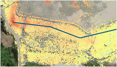
Multi-temporal SAR and optical data reveal cut and fill history, soil-driven motion, and grading anomalies across entire sites without sending crews onsite.

Historical and ongoing monitoring to detect subsidence, uplift, and slope motion across pads and corridors

.png)
Identifies risks to foundation from cut and fill history and subsurface variability

.png)
Tracks site changes with time-slice maps,and pre/post overlays for design review.

.png)
Parses geotechnical reports, piling logs, and permits, delivered as structured summaries for quick review.


Explore our comprehensive suite of products for remote site monitoring and due diligence, applicable to large-scale projects in pre and post-construction phases.

48-hour historical baseline processing and 24-hours for ongoing monitoring.
Data access through our platform or delivery of raw data in standard interoperable formats.
Interpretation by seasoned geotechnical experts assisted by AI, for high accuracy and speed.
KorrAI’s technology prowess is very evident from their unique approach using ground-based IoT sensors to increase reliability of InSAR and deliver more robust reporting.
They are making InSAR more cost effective, intelligent, and accessible for large scale asset monitoring.
Whether it’s technical assistance or collaborative partnership, the team is always available and proactive.
In an industry dominated by legacy players, working with their team is nothing short of epic.


